After a patio lunch we follow Cottonwood Creek up to Cottonwood Pass, elevation 12,126ft. We go for a hike and bag an unnamed peak. We name it Cache la Poudre Dixie Doodlebug Sky Blue Mountain. The road turns to gravel as we drop into the Gunnison National Forest and take a campsite along the Taylor River.
,+Central+Colorado.JPG) |
| Cottonwood Pass, elevation 12,126ft, at the Continental Divide. |
,+Central+Colorado.JPG) |
| View from Cottonwood Pass. |
,+Central+Colorado.JPG) |
| Mitch hiking up the Cache la Poudre Dixie Doodlebug Sky Blue Mountain at Cottonwood Pass |
,+Central+Colorado.JPG) |
| Another view from the Cache la Poudre Dixie Doodlebug Sky Blue Mountain at Cottonwood Pass |
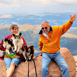
,+Central+Colorado.JPG) |
| Mitch on top of Cache la Poudre Dixie Doodlebug Sky Blue Mountain |
,+Central+Colorado.JPG) |
| Looking down from the Cache la Poudre Dixie Doodlebug Sky Blue Mountain at the RV |
,+Central+Colorado.JPG) |
| Peggy and Sky Blue |
No comments:
Post a Comment