As we enter Gunnison we see we have just missed the annual cowboy parade. We fill the propane tank and head east. We go over Monarch Pass, 11, 312 ft, and notice there is a coating of white from a recent hail storm. It seems to rain every afternoon up here in the mountains. We cruise into Buena Vista in time for supper. We have just completed a 2 day 200 mile loop through some of the most beautiful Rocky Mountains. We take a short hike across the Arkansas River and up the Barbara Whipple trail and take a seat on a bench overlooking Buena Vista and greet hikers as they pass by. We spend another night beside the RR tracks. Peggy stays up to monitor the partiers on Main Street.
Saturday, July 14, 2012
CENTRAL COLORADO, BUENA VISTA
The big sport on this side of the mountain is 4-wheeling. There are off-road trails and off-road vehicles everywhere. We head downstream and come to Taylor Lake which has a marina and a lot of boats on the water. As we leave the National Forest the river becomes lined with log cabins and lodges. When we leave Taylor Canyon the road turns back to pavement as we head toward Gunnison.
As we enter Gunnison we see we have just missed the annual cowboy parade. We fill the propane tank and head east. We go over Monarch Pass, 11, 312 ft, and notice there is a coating of white from a recent hail storm. It seems to rain every afternoon up here in the mountains. We cruise into Buena Vista in time for supper. We have just completed a 2 day 200 mile loop through some of the most beautiful Rocky Mountains. We take a short hike across the Arkansas River and up the Barbara Whipple trail and take a seat on a bench overlooking Buena Vista and greet hikers as they pass by. We spend another night beside the RR tracks. Peggy stays up to monitor the partiers on Main Street.
As we enter Gunnison we see we have just missed the annual cowboy parade. We fill the propane tank and head east. We go over Monarch Pass, 11, 312 ft, and notice there is a coating of white from a recent hail storm. It seems to rain every afternoon up here in the mountains. We cruise into Buena Vista in time for supper. We have just completed a 2 day 200 mile loop through some of the most beautiful Rocky Mountains. We take a short hike across the Arkansas River and up the Barbara Whipple trail and take a seat on a bench overlooking Buena Vista and greet hikers as they pass by. We spend another night beside the RR tracks. Peggy stays up to monitor the partiers on Main Street.

Friday, July 13, 2012
CENTRAL COLORADO, BUENA VISTA TO GUNNISON NATIONAL FOREST
We find we have parked in front of a river outfitter and now there are river rats everywhere trying to get ready. We move to the county park put-in where we try to wear out the dogs in the cold Arkansas River.
After a patio lunch we follow Cottonwood Creek up to Cottonwood Pass, elevation 12,126ft. We go for a hike and bag an unnamed peak. We name it Cache la Poudre Dixie Doodlebug Sky Blue Mountain. The road turns to gravel as we drop into the Gunnison National Forest and take a campsite along the Taylor River.
After a patio lunch we follow Cottonwood Creek up to Cottonwood Pass, elevation 12,126ft. We go for a hike and bag an unnamed peak. We name it Cache la Poudre Dixie Doodlebug Sky Blue Mountain. The road turns to gravel as we drop into the Gunnison National Forest and take a campsite along the Taylor River.
 |
| Cottonwood Pass, elevation 12,126ft, at the Continental Divide. |
 |
| View from Cottonwood Pass. |
 |
| Mitch hiking up the Cache la Poudre Dixie Doodlebug Sky Blue Mountain at Cottonwood Pass |
 |
| Another view from the Cache la Poudre Dixie Doodlebug Sky Blue Mountain at Cottonwood Pass |
 |
| Mitch on top of Cache la Poudre Dixie Doodlebug Sky Blue Mountain |
 |
| Looking down from the Cache la Poudre Dixie Doodlebug Sky Blue Mountain at the RV |
 |
| Peggy and Sky Blue |
Thursday, July 12, 2012
CENTRAL COLORADO, CRIPPLE CREEK TO BUENA VISTA, COLOARDO
We then cruise through the sister town of Victor which had just as many mines but no gambling license. Consequently it is not as developed. We return through Cripple Creek and count 15 casinos. They bring the gamblers in by the bus loads. Most of them are older than me.
We visit Florissant Fossil Beds National Monument and take a walk through the petrified forest. These redwood rocks are 35 million years old. The museum has collected over ten thousand fossils. They have a specimen of an ancient wasp (Palaeovespa) that is still alive today. We have supper in Buena Vista and park for the night beside the RR tracks.
 |
| Town of Cripple Creek with inactive volcano in the background |
 |
| Cripple Creek and Victor Gold Company, open pit mine currently in operation today |
 |
| Just a lovely view around the Cripple Creek and Victor area |
 |
| Mollie Kathleen Hard Rock Gold Mine |
 |
| Cage that dropped us 1,000 feet into the mine |
 |
| Another mine that intersected with the Mollie Kathleen mine |
 |
| Mike, our guide, demonstrating the drill used for drilling holes to place the dynamite in |
 |
| How the dynamite was laid out in the drilled holes |
 |
| This is called a stoke and is 780 feet up. They drilled up and let the ore fall down, using gravity |
 |
| Every miner needs a bathroom break |
 |
| Workshop for mining equipment repairs |
 |
| Look closely...there is a vein of gold |
 |
| This bucket would be loaded with ore, pulled up... |
 |
| ...and up |
 |
| Then dumped...very labor intensive |
 |
| Bells used to communicate with those above ground |
 |
| Gold Mine Tour Hard Rock Diner |
 |
| Mitch remembering back in the day when he operated a sawmill |
 |
| Mollie Kathleen Gortner, owner |
 |
| Petrified Redwood Tree at the Florissant Fossil Beds National Monument |
 |
| Mitch standing in front of another petrified Redwood Tree |
 |
| Fossilized Palaeovespa, an ancient wasp |
 |
| Black-tailed deer and her fawns feeding in the front yard of a house in Buena Vista |
Wednesday, July 11, 2012
CENTRAL COLORADO, CRIPPLE CREEK
Mueller State Park does not allow dogs on the hiking trails so we have to use disguises. Dixie will be a baby grizzly, Sky will be a baby black bear and Poudre will be a skunk.
We pull into Cripple Creek with enough time to have breakfast. This place was the largest gold field in the world at the turn of the century. Almost 50,000 people lived here then. Like most gold rush towns this one declined but got a reprieve in 1992 when Colorado started to allow gambling. Now it is a mini mecca of the sport with every other building being a casino.
We walk both sides of the main street and are amazed at the large number of cigarette butts on the sidewalk, and this is with ash trays at every entrance. Thank goodness for fresh mountain air. We visit the jail and then take a ride on the Cripple Creek and Victor Narrow Gauge Railroad. The four mile trip takes us through the old mine fields. We weather a hail storm that is really loud in the motor home. We dine at McGill's Casino and notice the strained expressions on peoples faces as they gamble. They are especially noticeable on those playing poker. We park for the night in the Midnight Rose Casino lot.
We pull into Cripple Creek with enough time to have breakfast. This place was the largest gold field in the world at the turn of the century. Almost 50,000 people lived here then. Like most gold rush towns this one declined but got a reprieve in 1992 when Colorado started to allow gambling. Now it is a mini mecca of the sport with every other building being a casino.
We walk both sides of the main street and are amazed at the large number of cigarette butts on the sidewalk, and this is with ash trays at every entrance. Thank goodness for fresh mountain air. We visit the jail and then take a ride on the Cripple Creek and Victor Narrow Gauge Railroad. The four mile trip takes us through the old mine fields. We weather a hail storm that is really loud in the motor home. We dine at McGill's Casino and notice the strained expressions on peoples faces as they gamble. They are especially noticeable on those playing poker. We park for the night in the Midnight Rose Casino lot.
 |
| Cripple Creek, Colorado |
 |
| Town of Cripple Creek |
 |
| Looking down main street. |
 |
| The Bad Ass Gambling Casino |
 |
| This 24K gold motorcycle was inside the Bad Ass Casino |
 |
| Outlaws and Lawmen Jail Museum |
 |
| There really is a Tommy the Train! (Cripple Creek and Victor Narrow Gauge Railroad) |
 |
| Headframe used in gold mining and old train depot in Cripple Creek. |
 |
| Prospect holes near Cripple Creek. |
 |
| El Paso gold mine near Cripple Creek. In its day it produced around $15,000,000. |
 |
| Cripple Creek and Victor Gold Mining Company in 2012. |
 |
| Old town of Anaconda at base of what is now the Cripple Creek and Victor Gold Company. |
 |
| Remaining structure in the what used to be the town of Anaconda- Blacksmith shop. |
 |
| Who pushed over the outhouse? |
 |
| Old Midland Depot, now a museum. |
 |
| Mitch advising Bob Womack how to hang onto his gold. |
 |
| Honey, I'm home. |
 |
| I just need a room for one night. |
 |
| Drinks are on me. |
Tuesday, July 10, 2012
CENTRAL COLORADO, PIKES PEAK
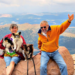
Today the Mitchell family bags Pikes Peak (14,110 feet). The road up would have been a lot more fun on a motorcycle. Oxygen is sparse up here. We're out of breath just walking to the gift shop. The place is named for a fellow who didn't even make it to the top. In 1806 he quit after several days and said it couldn't be done. The first white man to climb it was botanist Edwin James in 1820.
We search for and find the peak's Bench Mark, set in 1947, the year I was born. I remember being here in the 1950's to watch my Aunt and Uncle square dance. A lot of records have been set here. One fellow pushed a peanut with his nose up the mountain. It took him 20 days and he wore out five pairs of gloves. The fastest marathon time was 3 hours 16 minutes and the fastest road race time was 9:15 minutes with a motorcycle on the 12.46 mile, 7% road.
At the mandatory break test stop we're told our breaks are too hot and we have to let them cool down. The visitors center is conveniently close by. We also take the dogs for a hike to a nearby abandoned campground. We finally make it back down and head for Cripple Creek. We take a site at Mueller State Park for the night.
We search for and find the peak's Bench Mark, set in 1947, the year I was born. I remember being here in the 1950's to watch my Aunt and Uncle square dance. A lot of records have been set here. One fellow pushed a peanut with his nose up the mountain. It took him 20 days and he wore out five pairs of gloves. The fastest marathon time was 3 hours 16 minutes and the fastest road race time was 9:15 minutes with a motorcycle on the 12.46 mile, 7% road.
At the mandatory break test stop we're told our breaks are too hot and we have to let them cool down. The visitors center is conveniently close by. We also take the dogs for a hike to a nearby abandoned campground. We finally make it back down and head for Cripple Creek. We take a site at Mueller State Park for the night.
 |
| Drive up to Pikes Peak |
 |
| View from the drive up |
 |
| Big Horn Sheep grazing |
 |
| Oh! You wanted my picture? |
 |
| Katherine Bates in 1895 wrote 'America the Beautiful' after visiting Pikes Peak |
 |
| View from the top of Pikes Peak |
 |
| The clouds were amazing. |
 |
| Alpine Plant |
 |
| Peggy enjoying this beautiful day. |
 |
| Bench Mark dated 1947 |
 |
| Pikes Peak in the clouds |
 |
| Alpine flowers |
 |
| More alpine flowers |
 |
| Original Summit House constructed 1873. |
 |
| Mitchell Family |
 |
| Peg and her 4-legged kids |
 |
| Pikes Peak Cog Railway |
 |
| The road heading down Pikes Peak |
Subscribe to:
Posts (Atom)